

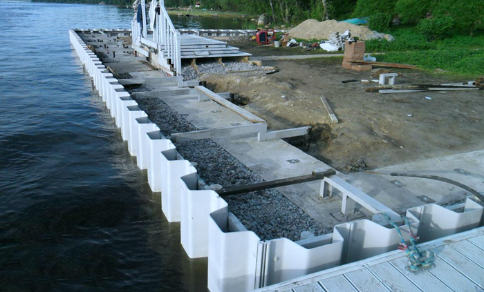
A shoreline structure is an engineering installation designed to reinforce the coastline, minimize soil erosion, and protect the area from waves, currents, and seasonal water level fluctuations. Such solutions are employed along rivers, lakes, reservoirs, and coastal waters where the natural stability of the bank is insufficient for the safe use of the site.
To ensure the structure lasts for decades, it is crucial to assess hydrological conditions, soil properties, and anticipated loads in advance, as well as to select the appropriate structural type and installation method. Errors during the design phase often lead to wall tilting, drainage system failure, undermining of the base, and accelerated structural deterioration.
Stages of Shoreline Structure Construction
-
- Site assessment and data collection. Engineering surveys are conducted, including analysis of shore-forming processes, depth measurements, evaluation of currents and wave action, soil investigation, and recording of seasonal water levels and potential flood zones.
- Design and calculations. The structure type, height, embedment depth, anchoring or buttress layout, foundation requirements, and drainage and filter layer parameters are determined. A safety margin is incorporated to account for soil heaving, erosion, and dynamic loads.
- Site preparation. Access routes, temporary decking, safe storage areas, and surface water drainage systems are established. Where necessary, clearing, grading, temporary slope stabilization, and water turbidity control measures are carried out.
- Base construction. Excavation or fill operations are performed, a crushed stone and sand bedding layer is created, geotextile is laid (acting as a filter and layer separator), and the material is compacted.
On weak soils, methods such as soil replacement, pile foundations, or geogrid reinforcement are employed.
- Installation of the load-bearing structure. The wall or reinforcement elements—such as sheet piles, blocks, gabions, piles, or pile caps—are installed. Verticality, elevations, joints, and watertightness are monitored. This stage often involves the residential bulkhead installation to protect private properties, where precise geometry and neat integration with the existing terrain are crucial.
- Drainage and water discharge. A filter layer, drainage pipes, spillways, or weep holes (if specified in the design) are installed. Drainage reduces hydrostatic pressure behind the wall and minimizes the risk of bulging or displacement.
- Backfilling and compaction. Material is placed in layers—using suitable, typically free-draining fill—while monitoring moisture content and compaction levels. Improper backfilling is a common cause of settlement, void formation, and structural deformation.
- Shoreline stabilization and erosion protection. Toe protection (using stone, mattresses, or slabs) is installed to prevent undercutting. In areas exposed to wave action, wave-dissipating measures and slope reinforcement at transition points are added.
- Finishing works and landscaping. The top edge, railings, decking, stairs, platforms, and landscaping are constructed. It is important to maintain drainage functionality and avoid obstructing water discharge elements.
- Quality control and maintenance. As-built measurements are taken, records of concealed works are documented, and the drainage system is inspected.
During the operational phase, inspections are conducted following floods and storms; drainage systems are cleared; and checks are made for the formation of voids, scouring at the base, and corrosion of fasteners.
- Crucially, drainage, scour protection, and proper backfilling determine the structure’s service life just as much as the wall material itself.
- Rule of thumb: if the site shows signs of active erosion or weak soils, the solution must be based on a formal engineering design rather than an ad-hoc, on-site decision; otherwise, the risk of deformation increases sharply.
Summary: Why site geology and hydrology matter before design
The more accurate the initial data, the less uncertainty there is in calculations and the lower the likelihood of redesigns; furthermore, the behavior of the shoreline and soil—across different seasons and under extreme conditions—becomes more predictable. The outcome of the work is a set of materials that serves as the basis for selecting the structure type, design solutions, and shoreline protection measures.
Deliverables upon completion of data collection
- Engineering-geological model of the site: stratigraphy, engineering-geological units, physical and mechanical soil properties, and data on weak, collapsible, or swelling soil layers.
- Hydrogeological conditions: groundwater levels and regime, pressure conditions, water aggressiveness toward materials, and risks of seepage and suffusion.
- Hydrological regime of the water body/watercourse: water level fluctuations, currents, wave action (if applicable), ice phenomena, and scour and sediment transport.
- Geomorphology and shoreline dynamics: shoreline type, slope processes, zones of active erosion/accretion, and shoreline evolution forecast.
- Field and laboratory data: results of drilling, sounding, and test pumping/monitoring, as well as soil and water test reports.
- Completeness check – comparing project objectives with actual data volume (sufficiency of data points and depth, seasonality of observations).
- Consistency – eliminating contradictions between field observations, laboratory data, and archival materials.
- Project delivery – formatting data into reports, diagrams, tables of calculated parameters, and source files for computational models.